


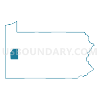
Butler County PUMA, Pennsylvania
About
Outline

Summary
| Unique Area Identifier | 193850 |
| Name | Butler County PUMA |
| State | Pennsylvania |
| Area (square miles) | 794.75 |
| Land Area (square miles) | 788.60 |
| Water Area (square miles) | 6.15 |
| % of Land Area | 99.23 |
| % of Water Area | 0.77 |
| Latitude of the Internal Point | 40.91383360 |
| Longtitude of the Internal Point | -79.91895990 |
Maps

Graphs
Select a template below for downloading or customizing gragh for Butler County PUMA, Pennsylvania


Neighbors
Neighoring Public Use Microdata Area (by Name) Neighboring Public Use Microdata Area on the Map
- Allegheny County (North)--Franklin Park Borough & Allison Park PUMA, PA
- Beaver County (South) PUMA, PA
- Indiana & Armstrong Counties PUMA, PA
- Lawrence & Beaver (North) Counties--New Castle City PUMA, PA
- Mercer County PUMA, PA
- Venango, Jefferson, Clarion & Forest Counties PUMA, PA
Top 10 Neighboring County (by Population) Neighboring County on the Map
- Allegheny County, PA (1,223,348)
- Butler County, PA (183,862)
- Beaver County, PA (170,539)
- Mercer County, PA (116,638)
- Lawrence County, PA (91,108)
- Armstrong County, PA (68,941)
- Venango County, PA (54,984)
- Clarion County, PA (39,988)
Top 10 Neighboring County Subdivision (by Population) Neighboring County Subdivision on the Map
- Cranberry township, Butler County, PA (28,098)
- Butler township, Butler County, PA (17,248)
- Butler city, Butler County, PA (13,757)
- West Deer township, Allegheny County, PA (11,771)
- Adams township, Butler County, PA (11,652)
- Pine township, Allegheny County, PA (11,497)
- Richland township, Allegheny County, PA (11,100)
- Harrison township, Allegheny County, PA (10,461)
- Center township, Butler County, PA (7,898)
- New Sewickley township, Beaver County, PA (7,360)
Top 10 Neighboring Place (by Population) Neighboring Place on the Map
- Butler city, PA (13,757)
- Fernway CDP, PA (12,414)
- Homeacre-Lyndora CDP, PA (6,906)
- Shanor-Northvue CDP, PA (5,051)
- Meridian CDP, PA (3,881)
- Zelienople borough, PA (3,812)
- Slippery Rock borough, PA (3,625)
- Fox Run CDP, PA (3,282)
- Seven Fields borough, PA (2,887)
- Meadowood CDP, PA (2,693)
Top 10 Neighboring Unified School District (by Population) Neighboring Unified School District on the Map
- Butler Area School District, PA (54,849)
- North Allegheny School District, PA (50,013)
- Seneca Valley School District, PA (46,966)
- Armstrong School District, PA (43,364)
- Pine-Richland School District, PA (22,597)
- Highlands School District, PA (20,627)
- Slippery Rock Area School District, PA (20,583)
- Mars Area School District, PA (18,960)
- South Butler County School District, PA (18,499)
- Grove City Area School District, PA (17,699)
Top 10 Neighboring State Legislative District Lower Chamber (by Population) Neighboring State Legislative District Lower Chamber on the Map
- State House District 12, PA (70,527)
- State House District 28, PA (67,105)
- State House District 8, PA (62,230)
- State House District 11, PA (60,130)
- State House District 33, PA (59,492)
- State House District 64, PA (59,331)
- State House District 10, PA (58,463)
- State House District 60, PA (58,162)
- State House District 63, PA (56,952)
Top 10 Neighboring State Legislative District Upper Chamber (by Population) Neighboring State Legislative District Upper Chamber on the Map
- State Senate District 40, PA (256,162)
- State Senate District 41, PA (236,058)
- State Senate District 50, PA (235,966)
- State Senate District 21, PA (235,571)
- State Senate District 47, PA (225,797)
- State Senate District 38, PA (213,989)
Top 10 Neighboring 111th Congressional District (by Population) Neighboring 111th Congressional District on the Map
- Congressional District 5, PA (651,762)
- Congressional District 4, PA (647,418)
- Congressional District 3, PA (640,356)
- Congressional District 12, PA (612,384)
Top 10 Neighboring Census Tract (by Population) Neighboring Census Tract on the Map
- Census Tract 4090, Allegheny County, PA (11,497)
- Census Tract 9124.01, Butler County, PA (7,813)
- Census Tract 6018, Beaver County, PA (7,360)
- Census Tract 9127, Butler County, PA (7,307)
- Census Tract 4110, Allegheny County, PA (6,915)
- Census Tract 9124.02, Butler County, PA (6,483)
- Census Tract 9110, Butler County, PA (6,278)
- Census Tract 9118, Butler County, PA (6,189)
- Census Tract 9512, Armstrong County, PA (5,991)
- Census Tract 328, Mercer County, PA (5,948)
Top 10 Neighboring 5-Digit ZIP Code Tabulation Area (by Population) Neighboring 5-Digit ZIP Code Tabulation Area on the Map
- 16001, PA (40,371)
- 16101, PA (34,042)
- 16066, PA (28,060)
- 15044, PA (27,049)
- 16127, PA (16,145)
- 16002, PA (15,877)
- 16046, PA (14,396)
- 16057, PA (13,909)
- 15065, PA (11,588)
- 15084, PA (10,130)